
When I took my coffee out on to the lanai Wednesday (May 25) morning, I noticed a big ship in the distance coming this way. It turned out to be a cruise ship...there was one in port last Wednesday when we arrived, so it looks like Wednesday is their day here in Kailua-Kona.


We found our spot at the end of the beach and dropped our gear. Dave and Leslie had their own snorkeling gear, so after a dip in the water, they put on their gear and headed out to see what they could see.
The beach is absolutely stunning! White sand and clear turquoise/blue water...of course the blue sky makes it even better!


A high surf advisory was issued Thursday (May 26) making for great wave watching over the next few days! But after having a relaxing day yesterday, we decided to get out for more sightseeing...this time to see the Hamakua Coast.
Located just north of Hilo on the northeastern side of the island of Hawaii, the Hamakua Coast is one of the most beautiful stretches of scenery on the island. With nearly 84 inches of rainfall a year, the region boasts lush tropical rainforests, stunning waterfalls and tranquil green valleys.
During most of the 19th and 20th centuries, the Hamakua Coast was covered with sugar cane. Today, communities can still be found where small farmers grow kalo (taro), hearts of palm, vegetables and tropical fruit. Small towns like Historic Honokaa Town also feature specialty shops and boutiques with their own local flavor.We headed north (and northeast) on highway 19 and continued past Waimea to Honoka'a. Beautiful scenery along the way. Here you can see where the greenery begins as we continue to climb...


At Honoka'a, we took highway 240 north to the end of the road and Waipi'o Valley Lookout...
Located on the Hamakua Coast, the sacred Waipio Valley was the boyhood home of King Kamehameha I, and an important center for political and religious life in Hawaii. Not only is "The Valley of the Kings" an important site for Hawaiian history and culture, it's also a place of dramatic tropical beauty.This fertile valley is about one mile across and over five-miles deep, and surrounded by cliffs up to 2000-feet high. Waipio Valley was once the home of thousands of Native Hawaiians. Today, there are less than 100 residents living amongst the waterfalls, taro fields and rivers permeating the valley.
You can view the valley from the coastal Waipio Valley Overlook at the end of the Hamakua Heritage Corridor drive, The County of Hawaii issued an Emergency Rule announcing the closure of Waipio Valley Road to visitors as a precautionary safety measure and to further assess and mitigate the road’s conditions, effective Friday, February 25, 2022.

Beautiful! Many villagers perished here (159 Island wide) during the 1946 tsunami...


(Click on photo to enlarge)

We noticed this place on the way in, and thinking we might be able to get some fresh fruit, decided to stop on the way back...a cool place but really didn't have anything we wanted other than some small bananas. We had a walk around and then continued on our way.


Back at Honoka'a, we got back on highway 19 going south. Our next stop was at Laupahoehoe Point Beach Park...at the end of a very narrow, windy road. The park has a huge lawn and camping area, complete with pavilions and restrooms.

A manmade concrete breakwater shields a small boat launch within Laupahoehoe’s natural cove. A reasonable swell can rush up the ramp occasionally, so we strongly recommend parents keep a watchful eye. Chartered sport fishing companies take advantage of the bountiful waters off Laupahoehoe. Fishing can be very good from the beach all along the Laupahoehoe Point Beach Park and also directly from the breakwater.

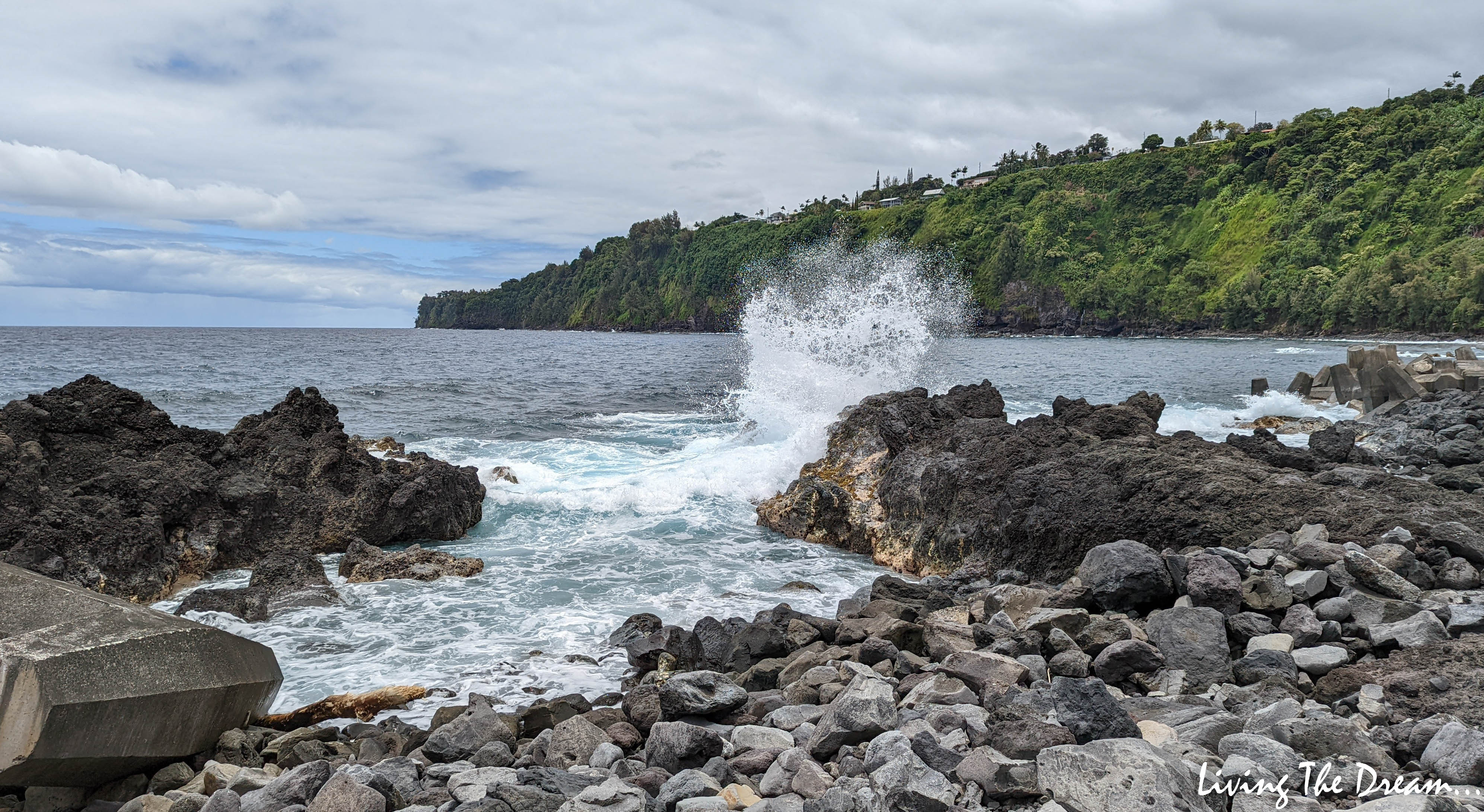

After an earthquake in Alaska’s Aelutian Islands on April 1st, 1946, a tsunami of three towering tidal waves hit the Big Island’s windward coast the hardest, ending the coastal rail and destroying much of Hilo killing 159 people, including 21 schoolchildren and three teachers in Laupahoehoe. Accounts recorded that the young students collected fish deposited from the huge, second wave on the school grounds while the teachers were in their cabin changing back into dry clothes when the final huge and deadly wave hit (estimated at 56 feet high moving 490 mph.)...

Such beautiful lush scenery in several gulches as we continue south along the coast highway...


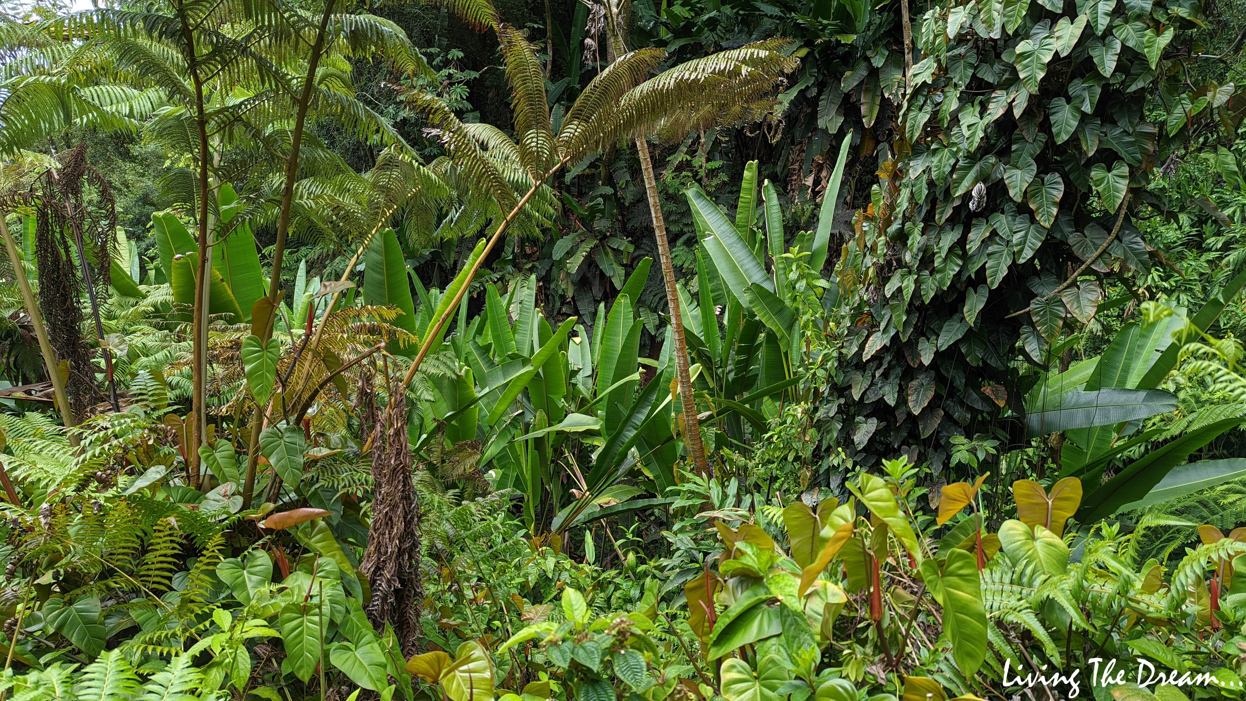
Our next stop was Akaka Falls State Park. After parking and paying the fee, we headed out on the paved .4-mile loop path that takes you through a lush rainforest.


Approaching the towering Akaka Falls...

...which plummets 442-feet into a stream-eroded gorge.


More scenery along the way as we continue south...

Just before Pepeekeo we left highway 19, taking a narrow, windy but scenic route that went closer to the coastline.


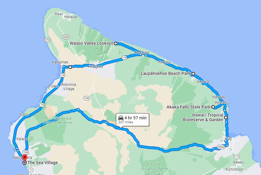
Our route today....
And another gorgeous sunset to end a great day...

Absolutely gorgeous waterfall hike pictures. So lush and such pretty flowers!
ReplyDeleteSuch a stark contrast from the lava fields on the west side!
DeleteAkaka and the other waterfalls are amazing! But that sunset in your last picture is my favorite!
ReplyDeleteWe had a few nice ones!
DeleteLooks like you guys saw almost all that the island has to explore. :) Great trip and pictures.
ReplyDeleteWe made good use of our time there!
DeleteBeautiful pictures !! Thanks for sharing
ReplyDeleteGlad to enjoyed them!
DeleteYou got some fantastic pics with that new phone. So glad you didn't erase my photo bomb lol. Waipio valley and the walk around the falls was a great day. The bamboo in there was huge! Cheers
ReplyDeleteAww...why would I want to erase you, Dave?☺️ Very happy with my new phone.. it worked well and was much more compact than the big Nikon!
Delete